Categories
- Agriculture / Farm
- Animals
- Arts / Crafts
- Beauty / Fashion
- Books / Literature
- Business / Finance
- Cities / Places
- Computers / IT
- Construction
- Materials & Supplies
- Ecology / Climate
- Educational
- Electronics
- Energy / Utilities
- Food / Drinks
- Games
- General
- Geography
- Geology
- Health / Fitness
- History
- Home / Garden
- Jobs / Careers
- Kids / School
- Law / Government
- Music / Movies / TV
- News / Media
- Occasions
- Christmas
- Easter
- Halloween
- New Year
- Saint Patrick's Day
- Thanksgiving
- Valentine's Day
- Outdoors
- Religion / Belief
- Safety / Prevention
- Science
- Astronomy
- Biology
- Chemistry
- Physics
- Seasonal
- Shopping
- Society / Culture
- Sports
- Tools / Equipment
- Travel / Tourism
- Vehicles
Geography Crossword Puzzles
Free printable geography crossword puzzles. Download pre-made or create your own Crossword using our crossword maker. Simply download, print and start playing or play online.
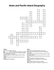
capital of the federated states of micronesia, the island where the capital of the cook islands is located, a large group of islands (sometimes known …
continued use of chemical fertilizer can cause ---- to build up, a desert located in southern, what river provides the sahel with water, area with a …
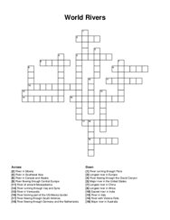
longest river in africa, river flowing through south america, longest river in china, major river in the united states, river flowing through central …
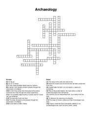
a person who studies ancient cultures through the examination of artifacts, to rot, or decay, created after the fact, it is not original, a replica of …
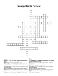
hero of an epic who travels the world performing great deeds, many sumerians were skilled at this, but had to trade to obtain their metals, during the …
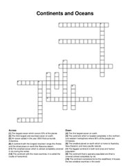
the third largest and warmest ocean on earth, the continent which is located completely in the northern and western hemisphere where 80% of the people …
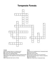
another word for rainfall, a broad leafed tree, trees that lose their leaves in winter are called this, a temperate forest has four of these, fraction …
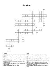
the act of carving a gully or channel by running water, large streams that carry water from the mountains to the ocean, land that borders a stream …
a collection of water droplets in the air, a stratus cloud on the ground, a white fluffy cloud, a flat cloud that covers the sky, thin wisps of …
low-density surface layer of a planet, wearing down or building up of geological features, dense central region of a planet that has undergone …
the force of the river against the banks, rocks carried by the river scrape along the bed and banks, smaller material that is light enough to be …
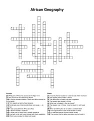
a pre-colonial west african state that was located in what is now southern ghana. this empire cultivated a high level of military prowess, wealth, …
a species that is in threat of extinction, growing crops and raising livestock, the introduction of harmful substances or products into the …
parts of this ocean remain frozen year round, this region's major landform is the rocky mountains, this region is famous for the grand banks and …
how did he feel about what he saw, who is considered as a god on earth, what did earlier pharaohs get buried in, what else divided pharaohs?(2words), …
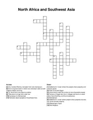
desert in southern africa, flows between atlantic ocean and central africa, generally regarded as the longest river in the world, sea between africa …
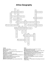
desert in southern africa, flows between atlantic ocean and central africa, generally regarded as the longest river in the world, sea between africa …
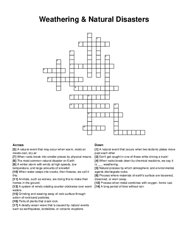
a long period of time without rain, animals, such as wolves, are doing this to make their homes in the ground, when water seeps into cracks, then …
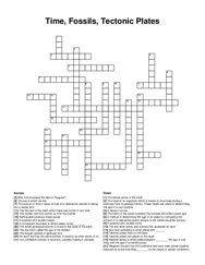
tectonic plates are pieces of this layer, sea floor spreading is when plates drift _ , the amount of time it takes for half of a radioactive sample to …
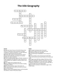
old, main mountain range in the eastern us, america\'s largest and most important river, enormous mountains in the western region of the united …
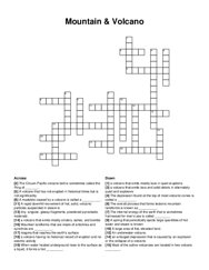
mountain landforms that are made of anticlines and synclines are _ , the depression found at the top of most volcanic cones is called a _ , a large …
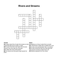
the natural force that pulls things towards the earth, a valley with many small streams, moisture squeezed from rain clouds, relating to or living in …
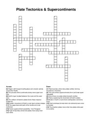
region with frequent earthquakes and volcanic activity around the pacific, sudden movement of earth's crust due to stress release, breaks in …
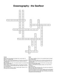
a system detecting objects under water by emitting sound pulses and measuring their return after reflection, flat-topped underwater mountain formed …
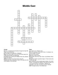
it is an extension of the gulf of oman. it is between iran and the arabian peninsula, middle east, bordering the mediterranean sea, between egypt and …
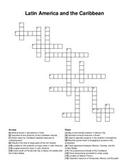
rural areas being converted to urban areas, brazilian government is struggling to preserve this ecosystem, big environmental problem in mexico city, …
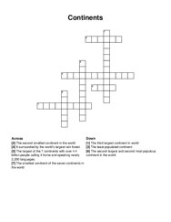
the second largest and second most populous continent in the world, the second smallest continent in the world, it surrounded by the world’s largest …
the physical phenomena arising from the behaviour of electrons and protons that is caused by the attraction of particles with opposite charges and the …
dry riverbed filled by rainwater from rare downpours, settlement in israel where people share property but also own some private property, settlement …
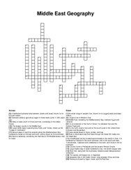
it is an extension of the gulf of oman. it is between iran and the arabian peninsula, middle east, bordering the mediterranean sea, between egypt and …