Survey Engineering Crossword Puzzle
Download and print this Survey Engineering crossword puzzle. Use a pencil or pen to complete the puzzle by filling in the blanks. The completed answers are included, so you can easily check your progress.
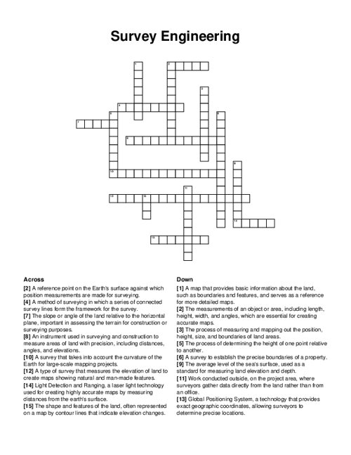
PDF will include puzzle sheet and the answer key.
Related puzzles:
More Educational Crossword Puzzles
Geotechnical Engineering
College Majors

Computer Science

Optical Engineering
Data Sets and Distribution
Browse all Educational Puzzles
QUESTIONS LIST:
- surveying: the process of measuring and mapping out the position, height, size, and boundaries of land areas.
- topographic survey: a type of survey that measures the elevation of land to create maps showing natural and man-made features.
- boundary survey: a survey to establish the precise boundaries of a property.
- geodetic survey: a survey that takes into account the curvature of the earth for large-scale mapping projects.
- traverse: a method of surveying in which a series of connected survey lines form the framework for the survey.
- total station: an instrument used in surveying and construction to measure areas of land with precision, including distances, angles, and elevations.
- base map: a map that provides basic information about the land, such as boundaries and features, and serves as a reference for more detailed maps.
- field work: work conducted outside, on the project area, where surveyors gather data directly from the land rather than from an office.
- dimensions: the measurements of an object or area, including length, height, width, and angles, which are essential for creating accurate maps.
- contour: the shape and features of the land, often represented on a map by contour lines that indicate elevation changes.
- lidar: light detection and ranging, a laser light technology used for creating highly accurate maps by measuring distances from the earth's surface.
- gps: global positioning system, a technology that provides exact geographic coordinates, allowing surveyors to determine precise locations.
- sea level: the average level of the sea's surface, used as a standard for measuring land elevation and depth.
- grade: the slope or angle of the land relative to the horizontal plane, important in assessing the terrain for construction or surveying purposes.
- leveling: the process of determining the height of one point relative to another.
- datum: a reference point on the earth's surface against which position measurements are made for surveying.